
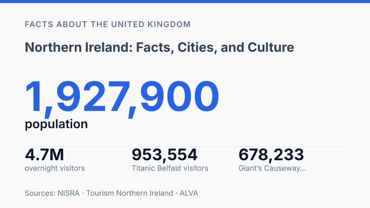
Northern Ireland fits less than a third of the island’s people into a space dense enough to average 141 people per km², nearly double the Republic of Ireland’s 73. Its population reached 1,927,900 on 30 June 2024, and growth came mainly from net migration.
That sounds tidy on a spreadsheet. It isn’t tidy on the ground.
The map explains part of it. So does Belfast, a capital-sized pull in a region where identity doesn’t line up neatly with borders.
British only, Irish only, and Northern Irish only all show up as major census answers. Irish and Ulster-Scots still matter too, but not in the same homes or communities.
This guide keeps the facts close to real places: cities, coasts, language, travel habits. The everyday labels people actually use. In my honest opinion, the mistake is treating this place as a footnote to Britain or Ireland, when its small size is exactly what makes it so layered.
Where Northern Ireland sits in the UK
The United Kingdom’s only land border with the European Union runs through the island of Ireland, making Northern Ireland the UK’s most geographically unusual constituent country.
It sits in the northeast of the island, across the North Channel from Scotland and directly beside the Republic of Ireland. It is not a county.
It is not part of England. It is one of the four constituent countries of the UK, alongside England, Scotland, and Wales.
Its present form dates to 1921, after the Government of Ireland Act and the partition of Ireland. That settlement created a UK jurisdiction made up of six counties: Antrim, Armagh, Down, Fermanagh, Londonderry, and Tyrone.
The border that followed was political. It cut across older routes, families, farms, and markets.
That geography still does real work. NISRA put the population at 1,927,900 on 30 June 2024.
This is a small place by UK standards. Yet CSO and NISRA figures show it accounts for 27% of the island’s population, with 141 people per square kilometre compared with 73 in the Republic.
In my view, the key twist is that Northern Ireland is both firmly part of the UK and deeply tied to the island of Ireland. That dual identity shapes politics, travel, and daily life.
You see it in road signs, currency habits, school choices, sport. The way people describe where they’re from.
Governance reflects that same tension. Laws and public services connect to the UK state, but devolved politics depends on power-sharing between communities with different constitutional loyalties. Under the Good Friday Agreement setup, David Trimble became the first First Minister and shared office with deputy First Minister Seamus Mallon.
That arrangement wasn’t just a technical fix. It recognized a hard truth: no single identity explains the place. The country’s position inside the UK is clear in law, but its island setting keeps Irish connections immediate, practical, and personal.
Belfast, Derry, and the main urban centres
Belfast can look oversized on the map of local life: one city concentrates government, port traffic, finance, universities. A large share of office work. Belfast is the capital and largest city, but its influence goes beyond politics.
Its harbour made it an industrial city first. The modern port still ties it to freight, ferries, logistics, and cross-channel trade.
The numbers explain why the pull feels so strong. With 1.9 million people, the region isn’t spread evenly across countryside and coast.
Most residents live in cities, large settlements, and commuter areas. On 30 June 2024, Northern Ireland’s population was 1,927,900, up 7,500 people from mid-2023, and NISRA said net migration was the main driver of that growth.
Yet Belfast doesn’t tell the whole urban story. Derry, officially Derry/Londonderry, is the second city and sits on the River Foyle near the north-western edge of the region. That geography matters. It gives the city a different outlook from Belfast: less tied to the eastern corridor, more connected to the north-west, and shaped by a borderland position that affects work, education, and daily movement.
Belfast gets the headlines, but Derry carries a different weight… and that split matters when you try to understand how the place actually works. One city dominates institutions and business services. The other anchors a region that would otherwise sit too far from the main administrative and economic centre. In my honest opinion, that imbalance is one of the clearest ways to read the region’s urban life.
Other centres matter most when seen through that pattern. Large settlements and commuter towns extend Belfast’s reach. The north-west looks to Derry for services, jobs, culture, and identity.
The result isn’t a neat two-city system. It’s a capital with exceptional pull, balanced by a second city whose importance grows the farther you get from Belfast.
Traditions, language, and everyday identity
The 2021 census put “British only” and “Irish only” identity less than three percentage points apart: 31.9% versus 29.1%, according to NISRA. “Northern Irish only” stood at 19.8%, which matters because it shows why any neat identity label fails fast here.
People don’t just inherit categories. They choose, mix, reject, and defend them.
Flags show that tension in its sharpest form. the Union flag and the Irish tricolour are the two most politically charged symbols in public debate, not just pieces of cloth on poles. A flag can mark loyalty, grief, territory, or exclusion. Sometimes it does all four at once.
Language carries the same weight, but in a quieter register. Irish and Ulster Scots are the main minority language traditions discussed in cultural policy, signage, education, and funding. The 2024/25 Continuous Household Survey found that 16% of adults had some knowledge of Irish and 19% had some knowledge of Ulster Scots, according to NISRA and the Department for Communities. Those figures aren’t huge, but they’re politically loud.
The social pattern is just as revealing. In the same survey, 35% of Catholics had some knowledge of Irish, compared with 3% of Protestants.
For Ulster Scots, the pattern reversed: 29% of Protestants reported some knowledge, compared with 13% of Catholics. Language here can be cultural curiosity, family memory, or political signal.
Public tradition makes the contrast harder to ignore. Orange Order parades on 12 July remain one of the clearest examples of a public custom that still sparks debate. For supporters, the parades express Protestant history and community pride. For critics, some routes feel like domination rather than celebration.
In my humble opinion, what’s often missed is that culture here isn’t just heritage. It’s public space, politics, and memory all at once. That’s why the same song, colour, street, or language sign can feel ordinary to one person and loaded to another.
Coasts, parks, and the places people travel to see
About 40,000 interlocking basalt columns make the north coast look engineered rather than eroded. Giant’s Causeway is the obvious icon: a UNESCO World Heritage Site shaped by ancient volcanic activity, then retold through the legend of Finn McCool. That mix matters.
The rocks pull in cameras. The stories give the place its grip.
The coast is easiest to picture from the road. Antrim Coast Road ranks among the best-known scenic drives in the UK, with cliffs, beaches, headlands, and villages pressed between sea and slope. It looks effortless from a car window. But that beauty can hide how tightly these places connect to fishing, migration, shipwrecks, and old routes between Scotland and Ireland.
The wider Causeway Coastal Route links many of the north coast’s best-known stops without needing to turn the area into a checklist. Carrick-a-Rede rope bridge adds a sharp dose of height and exposure.
Dunluce Castle brings ruin, sea air, and power into the same view. The Glens of Antrim soften the drama with wooded valleys and small settlements.
Parks and inland places shift the mood again. Glenariff Forest Park is known for waterfalls and walking trails.
Tollymore Forest Park, near the Mourne Mountains, has stone bridges, river paths, and woodland that feels older than the visitor signs suggest. Fermanagh’s lakes and Marble Arch Caves add a quieter western counterweight to the photographed coast.
Tourism Northern Ireland reported 4.7 million overnight visitors in 2024, with £1.1 billion spent, so these places aren’t minor extras to the economy. Still, the appeal isn’t just visitor numbers. In my view, the strongest sites here work because they refuse to be only pretty. They carry geology, folklore, local labour, and history in the same view.
What the map still can’t explain
Treat Northern Ireland as a checklist and you’ll miss the point. In 2024, visitors spent £1.1 billion, and Titanic Belfast pulled close to a million people through one door. But the quieter clue sits elsewhere: identity, language, and place still change street by street.
Use the big sights as anchors, not answers. Ask why a name appears in Irish here and Ulster-Scots there. Notice why the capital feels young and Ards and North Down feels older. In my humble opinion, the best way to read this place is slowly, with room for contradiction.
A small region can carry more than one truth. Here, it usually does.
Frequently Asked Questions
Q: Is Northern Ireland part of the UK or Ireland?
A: Northern Ireland is a constituent country of the United Kingdom. It sits in the northeast of the island of Ireland, so its geography and political status don’t match up neatly. That’s the part people mix up most.
Q: How many counties are in Northern Ireland?
A: There are six counties in Northern Ireland. That number matters because it shapes how people talk about the region, even if modern administration doesn’t follow county lines the way older maps did. It’s a small area. The identity is strong.
Q: What is the capital city of Northern Ireland?
A: Belfast is the capital. It’s the biggest city and the main center for business, culture, and transport. In my view, it’s also the best place to get a quick read on the region’s mix of history and modern life.
Q: How many people live in Northern Ireland?
A: The population is roughly 1.9 million. That makes it smaller than many people expect. It still has a dense cultural life and a strong urban center in Belfast. Size doesn’t tell the full story here.
Q: What is Northern Ireland known for culturally?
A: It’s known for a blend of British and Irish traditions. You’ll see that mix in language, sport, music, and public identity… and that tension is part of what makes the region distinctive. The coast is a draw too, with scenery that feels far bigger than the map suggests.